
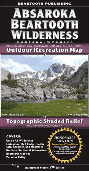
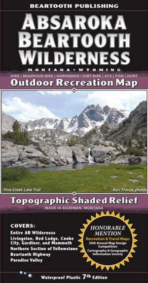
{"id":11202777732,"title":"Absaroka Mountain Range Map","handle":"absaroka-mountain-range-map","description":"\u003cp class=\"p1\"\u003eThe 937,005 acre Absaroka Beartooth is the sixth largest Wilderness area in the continental United States. It covers the northern section of the Absaroka Range and, to the east, the Beartooth Mountains. The Beartooths contain Montana’s highest summit (12,799 foot Granite Peak), hundreds of high elevation lakes, and one of the largest contiguous areas of peaks above 10,000 feet in the United States.\u003c\/p\u003e\n\u003cp class=\"p1\"\u003eThis map includes the entire AB Wilderness from Livingston to Red Lodge, the northern section of Yellowstone National Park, the Beartooth National Scenic Byway, and Paradise Valley.\u003c\/p\u003e\n\u003ctable class=\"shop_attributes\"\u003e\n\u003ctbody\u003e\n\u003ctr class=\"\"\u003e\n\u003cth\u003eScale\u003c\/th\u003e\n\u003ctd\u003e\n\u003cp\u003e1:100,000\u003c\/p\u003e\n\u003c\/td\u003e\n\u003c\/tr\u003e\n\u003ctr class=\"alt\"\u003e\n\u003cth\u003eContour Interval\u003c\/th\u003e\n\u003ctd\u003e\n\u003cp\u003e100 feet\u003c\/p\u003e\n\u003c\/td\u003e\n\u003c\/tr\u003e\n\u003ctr class=\"\"\u003e\n\u003cth\u003eSize Unfolded\u003c\/th\u003e\n\u003ctd\u003e\n\u003cp\u003e25.2 x 39.2 inches\u003c\/p\u003e\n\u003c\/td\u003e\n\u003c\/tr\u003e\n\u003ctr class=\"alt\"\u003e\n\u003cth\u003eSize Folded\u003c\/th\u003e\n\u003ctd\u003e\n\u003cp\u003e4.2 x 8.0 inches\u003c\/p\u003e\n\u003c\/td\u003e\n\u003c\/tr\u003e\n\u003ctr class=\"\"\u003e\n\u003cth\u003eLatest Printing\u003c\/th\u003e\n\u003ctd\u003e\n\u003cp\u003e7th edition, 2015\u003c\/p\u003e\n\u003c\/td\u003e\n\u003c\/tr\u003e\n\u003c\/tbody\u003e\n\u003c\/table\u003e","published_at":"2017-06-17T15:42:05-06:00","created_at":"2017-06-17T15:44:00-06:00","vendor":"Beartooth Publishing","type":"Books\/Maps","tags":["Maps","Type_Maps"],"price":1495,"price_min":1495,"price_max":1495,"available":false,"price_varies":false,"compare_at_price":null,"compare_at_price_min":0,"compare_at_price_max":0,"compare_at_price_varies":false,"variants":[{"id":43030068740,"title":"Default Title","option1":"Default Title","option2":null,"option3":null,"sku":"","requires_shipping":true,"taxable":true,"featured_image":null,"available":false,"name":"Absaroka Mountain Range Map","public_title":null,"options":["Default Title"],"price":1495,"weight":85,"compare_at_price":null,"inventory_quantity":0,"inventory_management":"shopify","inventory_policy":"deny","barcode":"9781887460095","requires_selling_plan":false,"selling_plan_allocations":[],"quantity_rule":{"min":1,"max":null,"increment":1}}],"images":["\/\/eastrosebudflyandtackle.com\/cdn\/shop\/products\/ABSA-Map-Cover-7th-Ed-302x576.jpg?v=1574387278"],"featured_image":"\/\/eastrosebudflyandtackle.com\/cdn\/shop\/products\/ABSA-Map-Cover-7th-Ed-302x576.jpg?v=1574387278","options":["Title"],"media":[{"alt":"Absaroka Mountain Range Map - East Rosebud Fly and Tackle","id":358776537187,"position":1,"preview_image":{"aspect_ratio":0.524,"height":576,"width":302,"src":"\/\/eastrosebudflyandtackle.com\/cdn\/shop\/products\/ABSA-Map-Cover-7th-Ed-302x576.jpg?v=1574387278"},"aspect_ratio":0.524,"height":576,"media_type":"image","src":"\/\/eastrosebudflyandtackle.com\/cdn\/shop\/products\/ABSA-Map-Cover-7th-Ed-302x576.jpg?v=1574387278","width":302}],"requires_selling_plan":false,"selling_plan_groups":[],"content":"\u003cp class=\"p1\"\u003eThe 937,005 acre Absaroka Beartooth is the sixth largest Wilderness area in the continental United States. It covers the northern section of the Absaroka Range and, to the east, the Beartooth Mountains. The Beartooths contain Montana’s highest summit (12,799 foot Granite Peak), hundreds of high elevation lakes, and one of the largest contiguous areas of peaks above 10,000 feet in the United States.\u003c\/p\u003e\n\u003cp class=\"p1\"\u003eThis map includes the entire AB Wilderness from Livingston to Red Lodge, the northern section of Yellowstone National Park, the Beartooth National Scenic Byway, and Paradise Valley.\u003c\/p\u003e\n\u003ctable class=\"shop_attributes\"\u003e\n\u003ctbody\u003e\n\u003ctr class=\"\"\u003e\n\u003cth\u003eScale\u003c\/th\u003e\n\u003ctd\u003e\n\u003cp\u003e1:100,000\u003c\/p\u003e\n\u003c\/td\u003e\n\u003c\/tr\u003e\n\u003ctr class=\"alt\"\u003e\n\u003cth\u003eContour Interval\u003c\/th\u003e\n\u003ctd\u003e\n\u003cp\u003e100 feet\u003c\/p\u003e\n\u003c\/td\u003e\n\u003c\/tr\u003e\n\u003ctr class=\"\"\u003e\n\u003cth\u003eSize Unfolded\u003c\/th\u003e\n\u003ctd\u003e\n\u003cp\u003e25.2 x 39.2 inches\u003c\/p\u003e\n\u003c\/td\u003e\n\u003c\/tr\u003e\n\u003ctr class=\"alt\"\u003e\n\u003cth\u003eSize Folded\u003c\/th\u003e\n\u003ctd\u003e\n\u003cp\u003e4.2 x 8.0 inches\u003c\/p\u003e\n\u003c\/td\u003e\n\u003c\/tr\u003e\n\u003ctr class=\"\"\u003e\n\u003cth\u003eLatest Printing\u003c\/th\u003e\n\u003ctd\u003e\n\u003cp\u003e7th edition, 2015\u003c\/p\u003e\n\u003c\/td\u003e\n\u003c\/tr\u003e\n\u003c\/tbody\u003e\n\u003c\/table\u003e"}
Absaroka Mountain Range Map

Related Products

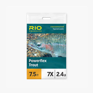
Rio Powerflex Tippet
From
$5.95

Slotted Tungsten Beads
From
$9.55
Ice Dub
$3.95
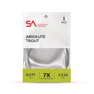
Scientific Anglers Absolute Trout Leaders
From
$8.95

ERFT Gift Card
From
$10.00
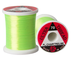
UTC 70 Denier Thread
$2.95

Uni Thread
From
$4.30
UTC 140 Denier Thread
$2.95

Cyclops Bead Eyes
$3.95