
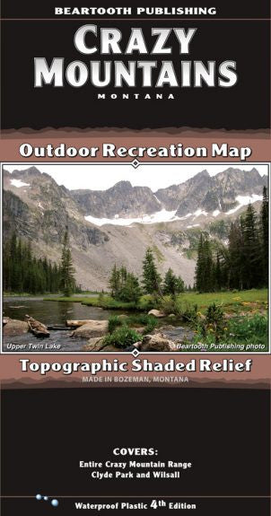
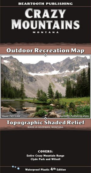
{"id":11202779396,"title":"Crazy Mountain Range Map","handle":"crazy-mountain-range-map","description":"\u003cp class=\"p1\"\u003eThis island range in southern Montana, north of the Absaroka and Beartooth Ranges, has a dedicated following of outdoor enthusiasts. There are about thirty peaks over 10,000 feet in elevation, most of them unnamed. The central, high elevation areas contain many alpine lakes, raging creeks, and small glaciers. The trails on the east side of the range are open to foot and horse travel only. On the west and north sides of the range there are many trails open to mountain bikes, and also several trails open to motorized travel.\u003c\/p\u003e\n\u003ctable class=\"shop_attributes\"\u003e\n\u003ctbody\u003e\n\u003ctr class=\"\"\u003e\n\u003cth\u003eScale\u003c\/th\u003e\n\u003ctd\u003e\n\u003cp\u003e1:50,000\u003c\/p\u003e\n\u003c\/td\u003e\n\u003c\/tr\u003e\n\u003ctr class=\"alt\"\u003e\n\u003cth\u003eContour Interval\u003c\/th\u003e\n\u003ctd\u003e\n\u003cp\u003e50 feet\u003c\/p\u003e\n\u003c\/td\u003e\n\u003c\/tr\u003e\n\u003ctr class=\"\"\u003e\n\u003cth\u003eSize Unfolded\u003c\/th\u003e\n\u003ctd\u003e\n\u003cp\u003e25.2 x 39.2 inches\u003c\/p\u003e\n\u003c\/td\u003e\n\u003c\/tr\u003e\n\u003ctr class=\"alt\"\u003e\n\u003cth\u003eSize Folded\u003c\/th\u003e\n\u003ctd\u003e\n\u003cp\u003e4.2 x 8.0 inches\u003c\/p\u003e\n\u003c\/td\u003e\n\u003c\/tr\u003e\n\u003ctr class=\"\"\u003e\n\u003cth\u003eLatest Printing\u003c\/th\u003e\n\u003ctd\u003e\n\u003cp\u003e4th edition, 2015\u003c\/p\u003e\n\u003c\/td\u003e\n\u003c\/tr\u003e\n\u003c\/tbody\u003e\n\u003c\/table\u003e","published_at":"2017-06-17T15:44:29-06:00","created_at":"2017-06-17T15:46:05-06:00","vendor":"Beartooth Publishing","type":"Books\/Maps","tags":["Maps","Type_Maps"],"price":1495,"price_min":1495,"price_max":1495,"available":false,"price_varies":false,"compare_at_price":null,"compare_at_price_min":0,"compare_at_price_max":0,"compare_at_price_varies":false,"variants":[{"id":43030105796,"title":"Default Title","option1":"Default Title","option2":null,"option3":null,"sku":"","requires_shipping":true,"taxable":true,"featured_image":null,"available":false,"name":"Crazy Mountain Range Map","public_title":null,"options":["Default Title"],"price":1495,"weight":85,"compare_at_price":null,"inventory_quantity":0,"inventory_management":"shopify","inventory_policy":"deny","barcode":"9781887460170","requires_selling_plan":false,"selling_plan_allocations":[],"quantity_rule":{"min":1,"max":null,"increment":1}}],"images":["\/\/eastrosebudflyandtackle.com\/cdn\/shop\/products\/Crazy-Mountains-Map-Cover-4th-Ed-302x575.jpg?v=1574388000"],"featured_image":"\/\/eastrosebudflyandtackle.com\/cdn\/shop\/products\/Crazy-Mountains-Map-Cover-4th-Ed-302x575.jpg?v=1574388000","options":["Title"],"media":[{"alt":"Crazy Mountain Range Map - East Rosebud Fly and Tackle","id":358776569955,"position":1,"preview_image":{"aspect_ratio":0.525,"height":575,"width":302,"src":"\/\/eastrosebudflyandtackle.com\/cdn\/shop\/products\/Crazy-Mountains-Map-Cover-4th-Ed-302x575.jpg?v=1574388000"},"aspect_ratio":0.525,"height":575,"media_type":"image","src":"\/\/eastrosebudflyandtackle.com\/cdn\/shop\/products\/Crazy-Mountains-Map-Cover-4th-Ed-302x575.jpg?v=1574388000","width":302}],"requires_selling_plan":false,"selling_plan_groups":[],"content":"\u003cp class=\"p1\"\u003eThis island range in southern Montana, north of the Absaroka and Beartooth Ranges, has a dedicated following of outdoor enthusiasts. There are about thirty peaks over 10,000 feet in elevation, most of them unnamed. The central, high elevation areas contain many alpine lakes, raging creeks, and small glaciers. The trails on the east side of the range are open to foot and horse travel only. On the west and north sides of the range there are many trails open to mountain bikes, and also several trails open to motorized travel.\u003c\/p\u003e\n\u003ctable class=\"shop_attributes\"\u003e\n\u003ctbody\u003e\n\u003ctr class=\"\"\u003e\n\u003cth\u003eScale\u003c\/th\u003e\n\u003ctd\u003e\n\u003cp\u003e1:50,000\u003c\/p\u003e\n\u003c\/td\u003e\n\u003c\/tr\u003e\n\u003ctr class=\"alt\"\u003e\n\u003cth\u003eContour Interval\u003c\/th\u003e\n\u003ctd\u003e\n\u003cp\u003e50 feet\u003c\/p\u003e\n\u003c\/td\u003e\n\u003c\/tr\u003e\n\u003ctr class=\"\"\u003e\n\u003cth\u003eSize Unfolded\u003c\/th\u003e\n\u003ctd\u003e\n\u003cp\u003e25.2 x 39.2 inches\u003c\/p\u003e\n\u003c\/td\u003e\n\u003c\/tr\u003e\n\u003ctr class=\"alt\"\u003e\n\u003cth\u003eSize Folded\u003c\/th\u003e\n\u003ctd\u003e\n\u003cp\u003e4.2 x 8.0 inches\u003c\/p\u003e\n\u003c\/td\u003e\n\u003c\/tr\u003e\n\u003ctr class=\"\"\u003e\n\u003cth\u003eLatest Printing\u003c\/th\u003e\n\u003ctd\u003e\n\u003cp\u003e4th edition, 2015\u003c\/p\u003e\n\u003c\/td\u003e\n\u003c\/tr\u003e\n\u003c\/tbody\u003e\n\u003c\/table\u003e"}
Crazy Mountain Range Map

Related Products
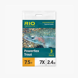

Rio Powerflex Tippet
From
$5.95

Slotted Tungsten Beads
From
$9.55
Ice Dub
$3.95
Scientific Anglers Absolute Trout Leaders
From
$8.95

ERFT Gift Card
From
$10.00

UTC 70 Denier Thread
$2.95

Uni Thread
From
$4.30
UTC 140 Denier Thread
$2.95

Cyclops Bead Eyes
$3.95