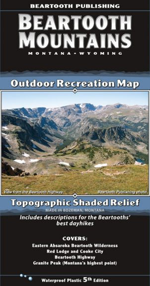
{"id":11202776004,"title":"Beartooth Mountain Range Map","handle":"beartooth-mountain-range-map","description":"\u003cp\u003eThis map is basically the southeast section of our Absaroka Beartooth Wilderness map expanded to twice its scale. This is a detailed map of the Beartooth Mountains only, from Red Lodge to the Northeast Entrance of Yellowstone National Park.\u003c\/p\u003e\n\u003cp\u003eThis is the only topographic map available which covers all of the Beartooths at a scale ideal for hiking and backpacking. It includes descriptions for ten local dayhikes. It shows the entire Beaten Path backpacking route (that’s the most common question we get about this map).\u003c\/p\u003e\n\u003ctable class=\"shop_attributes\"\u003e\n\u003ctbody\u003e\n\u003ctr class=\"\"\u003e\n\u003cth\u003eScale\u003c\/th\u003e\n\u003ctd\u003e\n\u003cp\u003e1:50,000\u003c\/p\u003e\n\u003c\/td\u003e\n\u003c\/tr\u003e\n\u003ctr class=\"alt\"\u003e\n\u003cth\u003eContour Interval\u003c\/th\u003e\n\u003ctd\u003e\n\u003cp\u003e50 feet\u003c\/p\u003e\n\u003c\/td\u003e\n\u003c\/tr\u003e\n\u003ctr class=\"\"\u003e\n\u003cth\u003eSize Unfolded\u003c\/th\u003e\n\u003ctd\u003e\n\u003cp\u003e25.2 x 39.2 inches\u003c\/p\u003e\n\u003c\/td\u003e\n\u003c\/tr\u003e\n\u003ctr class=\"alt\"\u003e\n\u003cth\u003eSize Folded\u003c\/th\u003e\n\u003ctd\u003e\n\u003cp\u003e4.2 x 8.0 inches\u003c\/p\u003e\n\u003c\/td\u003e\n\u003c\/tr\u003e\n\u003ctr class=\"\"\u003e\n\u003cth\u003eLatest Printing\u003c\/th\u003e\n\u003ctd\u003e\n\u003cp\u003e5th Edition, 2015\u003c\/p\u003e\n\u003c\/td\u003e\n\u003c\/tr\u003e\n\u003c\/tbody\u003e\n\u003c\/table\u003e","published_at":"2017-06-17T15:39:30-06:00","created_at":"2017-06-17T15:41:57-06:00","vendor":"Beartooth Publishing","type":"Books\/Maps","tags":["Maps","Type_Maps"],"price":1495,"price_min":1495,"price_max":1495,"available":true,"price_varies":false,"compare_at_price":null,"compare_at_price_min":0,"compare_at_price_max":0,"compare_at_price_varies":false,"variants":[{"id":43030019844,"title":"Default Title","option1":"Default Title","option2":null,"option3":null,"sku":"","requires_shipping":true,"taxable":true,"featured_image":null,"available":true,"name":"Beartooth Mountain Range Map","public_title":null,"options":["Default Title"],"price":1495,"weight":85,"compare_at_price":null,"inventory_quantity":2,"inventory_management":"shopify","inventory_policy":"deny","barcode":"9781887460132","requires_selling_plan":false,"selling_plan_allocations":[],"quantity_rule":{"min":1,"max":null,"increment":1}}],"images":["\/\/eastrosebudflyandtackle.com\/cdn\/shop\/products\/BEAR-Map-Cover-5th-Ed-302x575.jpg?v=1574387630"],"featured_image":"\/\/eastrosebudflyandtackle.com\/cdn\/shop\/products\/BEAR-Map-Cover-5th-Ed-302x575.jpg?v=1574387630","options":["Title"],"media":[{"alt":"Beartooth Mountain Range Map - East Rosebud Fly and Tackle","id":358776504419,"position":1,"preview_image":{"aspect_ratio":0.525,"height":575,"width":302,"src":"\/\/eastrosebudflyandtackle.com\/cdn\/shop\/products\/BEAR-Map-Cover-5th-Ed-302x575.jpg?v=1574387630"},"aspect_ratio":0.525,"height":575,"media_type":"image","src":"\/\/eastrosebudflyandtackle.com\/cdn\/shop\/products\/BEAR-Map-Cover-5th-Ed-302x575.jpg?v=1574387630","width":302}],"requires_selling_plan":false,"selling_plan_groups":[],"content":"\u003cp\u003eThis map is basically the southeast section of our Absaroka Beartooth Wilderness map expanded to twice its scale. This is a detailed map of the Beartooth Mountains only, from Red Lodge to the Northeast Entrance of Yellowstone National Park.\u003c\/p\u003e\n\u003cp\u003eThis is the only topographic map available which covers all of the Beartooths at a scale ideal for hiking and backpacking. It includes descriptions for ten local dayhikes. It shows the entire Beaten Path backpacking route (that’s the most common question we get about this map).\u003c\/p\u003e\n\u003ctable class=\"shop_attributes\"\u003e\n\u003ctbody\u003e\n\u003ctr class=\"\"\u003e\n\u003cth\u003eScale\u003c\/th\u003e\n\u003ctd\u003e\n\u003cp\u003e1:50,000\u003c\/p\u003e\n\u003c\/td\u003e\n\u003c\/tr\u003e\n\u003ctr class=\"alt\"\u003e\n\u003cth\u003eContour Interval\u003c\/th\u003e\n\u003ctd\u003e\n\u003cp\u003e50 feet\u003c\/p\u003e\n\u003c\/td\u003e\n\u003c\/tr\u003e\n\u003ctr class=\"\"\u003e\n\u003cth\u003eSize Unfolded\u003c\/th\u003e\n\u003ctd\u003e\n\u003cp\u003e25.2 x 39.2 inches\u003c\/p\u003e\n\u003c\/td\u003e\n\u003c\/tr\u003e\n\u003ctr class=\"alt\"\u003e\n\u003cth\u003eSize Folded\u003c\/th\u003e\n\u003ctd\u003e\n\u003cp\u003e4.2 x 8.0 inches\u003c\/p\u003e\n\u003c\/td\u003e\n\u003c\/tr\u003e\n\u003ctr class=\"\"\u003e\n\u003cth\u003eLatest Printing\u003c\/th\u003e\n\u003ctd\u003e\n\u003cp\u003e5th Edition, 2015\u003c\/p\u003e\n\u003c\/td\u003e\n\u003c\/tr\u003e\n\u003c\/tbody\u003e\n\u003c\/table\u003e"}
Beartooth Mountain Range Map


Related Products
Sold Out
Absaroka Mountain Range Map
$14.95
Sold Out
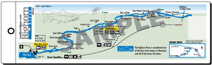
Bighorn Upper River Map
$7.95
Sold Out
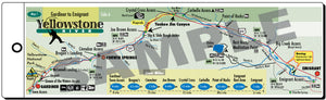
Yellowstone River Map
$7.95
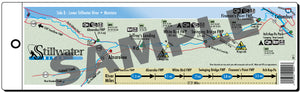
Stillwater River Map
$7.95
Sold Out
Sold Out
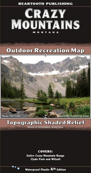
Crazy Mountain Range Map
$14.95
Sale

Barr Flies - John Barr
$23.95
$39.95
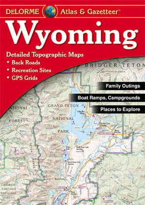
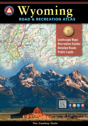
Atlas & Gazetteer - Wyoming
$24.95
Sold Out

Bighorn Lower River Map
$7.95